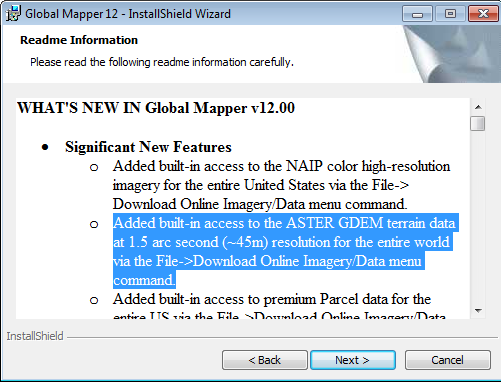
Download Data ASTER GDEM of Global Mapper 12 One new feature of Global Mapper 12 is the ability to download data from the earth's surface elevation Advanced Spaceborne Thermal Emission and Reflection Radiometer Global Digital Elevation Model (ASTER GDEM) through the Download menu Data Online.
Converting SHP to KML Along with her with Attribute Using SHP2KML Freeware 2.0
Previous GIS This blog has posted a way to convert shp to kml orkmz with its attributes by using the Global Mapper in the form ofmini-tutorials. You can also do the same by using the freewareSHP2KML 2.0 of Zonums.com.
SHP2KML is a free desktop application that does not requireinstallation, which is able to convert ESRI shapefile into a KML filefor display in Google Earth along with the selected attribute.Zonums.com creator freeware also has an online application to convert KML to SHP.
SHP2KML is a free desktop application that does not requireinstallation, which is able to convert ESRI shapefile into a KML filefor display in Google Earth along with the selected attribute.Zonums.com creator freeware also has an online application to convert KML to SHP.
Quantum GIS Using GIS Image
GIS image using Quantum GIS (QGIS) is as one alternative to usingopen source GIS software, in addition to GIS image using ArcGISExplorer (free download of the latest ESRI GIS Viewer is here).Previously also shown how to use the Global Mapper GIS containedin the e-book "Making GIS Image Results Download from Google Maps", as well as rectification of the image / image using ArcGISDesktop here.
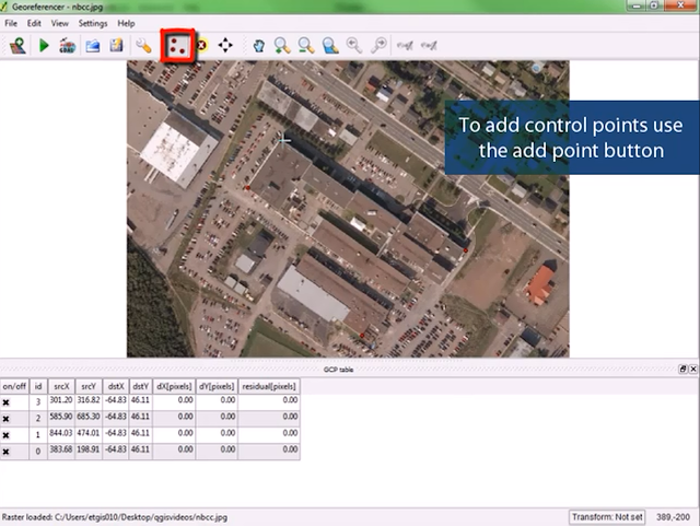
GIS in QGIS can be done using plugins Georeferencer. This pluginis the default when you install the Quantum GIS, which can be activated from the menu Plugins -> Select Georeferencer (QGIS1.6.0 Capiapo).
GIS in QGIS can be done using plugins Georeferencer. This pluginis the default when you install the Quantum GIS, which can be activated from the menu Plugins -> Select Georeferencer (QGIS1.6.0 Capiapo).
FUNCTIONS IN THE MENU ENVI
1. File Management Menu file in ENVI main menu is used to read the file into ENVI, set the options, to get out of ENVI, and program management functions & other files.
2. Display Menagement Window menu to control the display and ENVI plot window, including starting a new window, maximize window size, connect the display window, and close the window. Available Bands List and Available Vectors List fatherly featuring bands and vector layers. Window menu is also used to display the cursor location information and the pixel values in an image is displayed.
ENVY 4.3 SOFTWARE
ENVI (The Environment For visualizing Images) is a revolutionary image processing system made by Research System, Inc. (RSI).ENVI is designed for the many and specific needs are regularly using remote sensing data from satellites and peawat fly. ENVI uses a Graphical User Interfaca (GUI). ENVI uses raster data formats and Ascii (text) as the header file. Rester data is stored as 'binary stream of bytes' of formats Band Sequential (BSQ), Band Interleaved by Pixel (BIP) and Band Interkeaved by Line (BIL).ENVI also supports other formats such as various types: byte, interger, long interger, floating-point, double-precision, complex and double-precesion complex.
Definition of three-dimensional view of its use and association with Stereoskop
Commonly abbreviated three-dimensional or 3D or so-called space, is the shape of the object that has length, width, and height.This term is commonly used in art, animation, computers and mathematics. Remote sensing system of stereoscopic aerial photographs utilizing this technique to obtain information derived from air photo data series such as elevation, distance, volume and others. To produce a stereoscopic view of this, used observation tools that can generate stereoscopic views on the aerial photo that is stereoskop bertampalan. Through this stereoskop, objects contained in the patch area of the photo will look like three-dimensional images that can be measured height or depth of the object.
CITRA MODIS
MODIS is a sensor that is intended to provide data for land, seaand atmosphere on an ongoing basis. MODIS sensor mounted on the Terra satellite danAqua. Terra and Aqua satellites are alsodesigned to carry other sensors that AVHRRdan CZCS. Terra andAqua satellites have orbits the sun aligned (
sun synchronous
) Dandekat poles (
near-polar
). Satellites orbiting the Earth two days with 705kilometer altitudeabove the earth's surface.
Field of View
MODIS is ± 55o and width sapuan2330 km.Citra produced hasthree spatial resolution of 250 meters, 500 meters, dan1000meters. With a total of 36 fruit characteristic wavelength and 12-channel radiometric bitkepekaan. Terpasa MODIS sensor onthe Terra and Aqua satellites dapatmengukur almost all the parameters for land, sea and air so menjadisangat broadusefulness. Starting from the index plant, soil moisture, aerosollevels in air, sea suhupermukaan, and chlorophyll content of the sea, a total of 86 parameters sehinggabanyak other purposes that can be superimposed. Modis image may be obtainedgratismelalui reservations on the internet.
eNVI 4.6.1
ENVI is a remote sensing software used for mengolahcitra from satellites. ENVI provides a range of software solutions forpengolahandan analysis of geospatial imagery used by scientists,researchers, analysts images, and GIS professionals worldwide.ENVI gambardan processing solution combines the latesttechnology with intuitive spectral image analysis, the use ofmudahuntuk help us get meaningful information from images. Envimake suatucitra can more easily read, explored, prepared,analyzed, and berbagiinformasi of imagery with which lain.ENVI4.6.1 is a product version of ENVI. This software is widely used byberbakai circles around the world. Actually, the price is expensiveinisangat software. Only advantage for us is, ENVI release the oldproduct version after creating a new product version. So, becauseENVI 4.6.2 telahkeluar, then ENVI ENVI release version 4.6.1. Socan diaksessecara ENVI 4.6.1 free market. Therefore, in this lab,this software ENVI 4.6.1 which shall be used
Types of Encryption
Encryption is the process of securing the information by making such information can not be read without the help of specialized knowledge. The advantage of encryption is the original code we can not be read by others. This is also my experience writing in a race where about additional network security to the participants to do is to break the password has been changed in some form so that an understanding of the methods of encryption and hashing + salting know the concept is needed to crack passwords that exist.
Subscribe to:
Posts (Atom)