Google Maps Indonesia [http://maps.google.co.id] weather information is now available for almost all cities in Indonesia. Previously I've posted that on Google Earth, you can have a weather picture big cities in Indonesia. Features weather forecasts in Google Earth has been available since version 5.2 (now version 6). Like Google Earth, weather information on Google Maps uses data from Weather.com.

Weather information on Google Maps can be obtained by activating the weather feature (see image above). Weather information is indicated by the icon along with the magnitude of the weather picture of the temperature (in degrees Celsius) and the name of the city. If you click on the icon, then there is additional information that is humidity and wind speed forecast for today and up to 3 days ahead (see figure below).

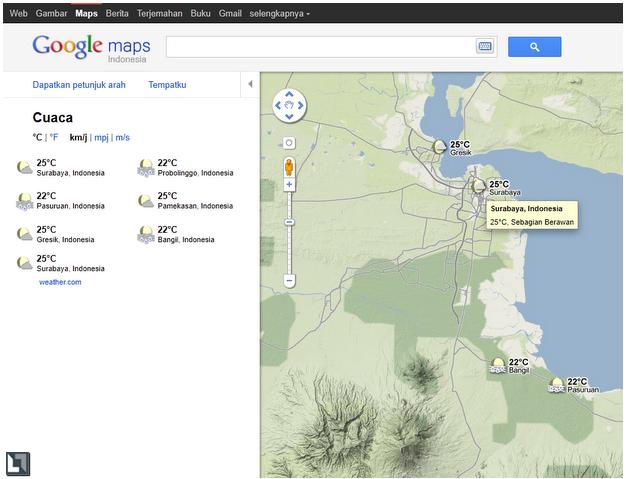
On the left there are other cities information contained in the surrounding area map view is user selected. For example I want to know weather information Surabaya city with zoom in to the city, then the information on weather in the city close to Surabaya will appear on the left. (see picture below)

Weather information is also available on the maps. google.com or otherwise available globally. Under the official video from Google about the weather feature on Google Maps. So now in addition to traffic information feature (Jakarta) and webcam (big cities in Indonesia), Google Maps has the complete features of the weather.

Weather information on Google Maps can be obtained by activating the weather feature (see image above). Weather information is indicated by the icon along with the magnitude of the weather picture of the temperature (in degrees Celsius) and the name of the city. If you click on the icon, then there is additional information that is humidity and wind speed forecast for today and up to 3 days ahead (see figure below).

On the left there are other cities information contained in the surrounding area map view is user selected. For example I want to know weather information Surabaya city with zoom in to the city, then the information on weather in the city close to Surabaya will appear on the left. (see picture below)
Weather information is also available on the maps. google.com or otherwise available globally. Under the official video from Google about the weather feature on Google Maps. So now in addition to traffic information feature (Jakarta) and webcam (big cities in Indonesia), Google Maps has the complete features of the weather.