ENVI EX is the latest addition in the ENVI software for image processing and analysis software products. ENVI is a selection of scientists and professional image for extracting accurate scientific information from the image. Now ENVI EX gives, scientifically accurate process to prove that ENVI is known in the workflow step-by-step revolutionary quick and easy guide you through advanced image processing tasks, regardless of the level of experience using it.

ENVI EX is a pretty amazing device with dynamic display that allows to quickly see the results of remote sensing or image manipulation, vector, and explanations. Tampilanya provides quick access to common tools such as the display contrast, brightness, sharpen, and color transparency in the image. Can work with multiple layers of data at a time and in one window, using the Data Manager and Layer Manager to keep track of multiple datasets, and "punch through" layer to see and work with one layer or another layer in the same window. In addition, ENVI EX can reproject and resample the image and vector-on-the-fly. ENVI EX works seamlessly with layers and features from ESRI and allows you to create professional map presentation.
For classification. You can optionally apply a subset of the space or spectral, and / or a mask for the input. Input classification requires a minimum of two bands. Iput types that are compatible ENVI, TIFF, NITF, JPEG 2000, JPEG, image Erdas, ESRI raster and raster geodatabase.
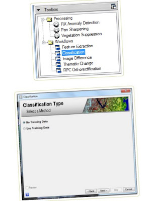
Guided and supervised classification can be done quickly, easily and seamlessly. Classification to be supervised more easily with the feature extraction / image segmentation of ENVI EX. Feature extraction method was first developed in graphic design software to "trace" feature / object seen in the picture, and the current ENVI and Idrisi also have applied this method to extract the information contained in the satellite imagery. Even ENVI EX has been combined (feature extraction) with the K-nearest neighborhood method to perform supervised classification directly. Feature extraction is very helpful in the job classification of LULC using satellite imagery, because this method can identify the LULC classes not only pixel-based, but also take into account in the interpretation of other components, such as shape and texture of the features / objects that appear in the image. Kedetailan level of accuracy and can be adjusted as needed. Other data such as elevation, slope, or NDVI can be added as the supporting data in the process of feature extraction.
ENVI EX is a pretty amazing device with dynamic display that allows to quickly see the results of remote sensing or image manipulation, vector, and explanations. Tampilanya provides quick access to common tools such as the display contrast, brightness, sharpen, and color transparency in the image. Can work with multiple layers of data at a time and in one window, using the Data Manager and Layer Manager to keep track of multiple datasets, and "punch through" layer to see and work with one layer or another layer in the same window. In addition, ENVI EX can reproject and resample the image and vector-on-the-fly. ENVI EX works seamlessly with layers and features from ESRI and allows you to create professional map presentation.
For classification. You can optionally apply a subset of the space or spectral, and / or a mask for the input. Input classification requires a minimum of two bands. Iput types that are compatible ENVI, TIFF, NITF, JPEG 2000, JPEG, image Erdas, ESRI raster and raster geodatabase.
Guided and supervised classification can be done quickly, easily and seamlessly. Classification to be supervised more easily with the feature extraction / image segmentation of ENVI EX. Feature extraction method was first developed in graphic design software to "trace" feature / object seen in the picture, and the current ENVI and Idrisi also have applied this method to extract the information contained in the satellite imagery. Even ENVI EX has been combined (feature extraction) with the K-nearest neighborhood method to perform supervised classification directly. Feature extraction is very helpful in the job classification of LULC using satellite imagery, because this method can identify the LULC classes not only pixel-based, but also take into account in the interpretation of other components, such as shape and texture of the features / objects that appear in the image. Kedetailan level of accuracy and can be adjusted as needed. Other data such as elevation, slope, or NDVI can be added as the supporting data in the process of feature extraction.