This time I will discuss its hydroprocessing ILWIS tool to extract patterns from data streams digital elevation model (DEM).
Knowledge of flow patterns is essential in many areas of science. For example, for the needs of geological analysis, PAS could be clues in the interpretation of rocks and geological structures. Some of the flow pattern that reflects berbeda2 different rocks. For the analysis of flood and irrigation, PAS is also used for analysis and determination of water catchment basin (watershed). PAS depends on the accuracy of the data base and scale DEM needs (ex: a regional scale or local scale).
Below is an example of how to extract the PAS with the technical baseline SRTM 90m DEM using ILWIS program.
Dataset: SRTM 90m DEM (GeoTiff)
Method: DEM hydroprocessing
Steps:
A. Import the SRTM DEM (tiff format) into ILWIS format using Import Geogateway
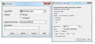
2. Operation - DEM hyroprocessing - Flow-Fill sink determination
and for all, terminology DEM replaced with file_Fillsink
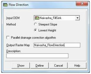
3. Operation - DEM hyroprocessing - Flow determination - Flow Direction
Input DEM: Naivasha_FillSink
Output: Naivasha_FlowDirection
4. Operation – DEM hyroprocessing – Flow determination – Flow Accumulation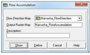
5. Operation – DEM hyroprocessing – Network and Catchment Extraction-Drainage Network Extraction
Input : Naivasha_FlowAccumulation
Output : Naivasha_NetworkExtraction
6. Operation – DEM hyroprocessing – Network and Catchment Extraction – Drainage Network Ordering
Input : Naivasha_NetworkExtraction
Output : Naivasha_ NetworkOrdering
Minimum drainage length:
Type a value for the minimum length (m) that a stream should have to remain in the drainage network. By choosing a larger value, fewer streams will remain in the drainage network; this will speed up the operation.
In this case, 300 m is the minimum length of the drainage created from the Network Extraction. It depends on which scale we were working on (personal opinion).
7. Operation – DEM hyroprocessing – Network and Catchment Extraction –
Input : Naivasha_ NetworkOrdering, Naivasha_FlowDirection
Output : Naivasha_CatchmentExtraction (polygon data,segment map).
8. Export Naivasha_CatchmentExtraction (polygon data) into *.shp format and open in ArcGIS.
9. Edit the drainage pattern and validate some of pattern which are not necessary using high image resolution (e.g Aster VNIR,Google Earth image etc)
Knowledge of flow patterns is essential in many areas of science. For example, for the needs of geological analysis, PAS could be clues in the interpretation of rocks and geological structures. Some of the flow pattern that reflects berbeda2 different rocks. For the analysis of flood and irrigation, PAS is also used for analysis and determination of water catchment basin (watershed). PAS depends on the accuracy of the data base and scale DEM needs (ex: a regional scale or local scale).
Below is an example of how to extract the PAS with the technical baseline SRTM 90m DEM using ILWIS program.
Dataset: SRTM 90m DEM (GeoTiff)
Method: DEM hydroprocessing
Steps:
A. Import the SRTM DEM (tiff format) into ILWIS format using Import Geogateway
2. Operation - DEM hyroprocessing - Flow-Fill sink determination
and for all, terminology DEM replaced with file_Fillsink
3. Operation - DEM hyroprocessing - Flow determination - Flow Direction
Input DEM: Naivasha_FillSink
Output: Naivasha_FlowDirection
4. Operation – DEM hyroprocessing – Flow determination – Flow Accumulation
5. Operation – DEM hyroprocessing – Network and Catchment Extraction-Drainage Network Extraction
Input : Naivasha_FlowAccumulation
Output : Naivasha_NetworkExtraction
6. Operation – DEM hyroprocessing – Network and Catchment Extraction – Drainage Network Ordering
Input : Naivasha_NetworkExtraction
Output : Naivasha_ NetworkOrdering
Minimum drainage length:
Type a value for the minimum length (m) that a stream should have to remain in the drainage network. By choosing a larger value, fewer streams will remain in the drainage network; this will speed up the operation.
In this case, 300 m is the minimum length of the drainage created from the Network Extraction. It depends on which scale we were working on (personal opinion).
7. Operation – DEM hyroprocessing – Network and Catchment Extraction –
Input : Naivasha_ NetworkOrdering, Naivasha_FlowDirection
Output : Naivasha_CatchmentExtraction (polygon data,segment map).
8. Export Naivasha_CatchmentExtraction (polygon data) into *.shp format and open in ArcGIS.
9. Edit the drainage pattern and validate some of pattern which are not necessary using high image resolution (e.g Aster VNIR,Google Earth image etc)