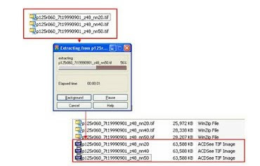
basically through two stages of the processing of initial and core processing. This initial processing of Landsat Data using ENVI 4.0 software to be made into a single dataset band 245. Then the next stage of processing is the core using ER Mapper 6.4 software with the formula if (i1/i2)> = 1 then 1 else if (i3/i2)> = 1 then 1 else 2. The second reason the use of such software is a habit and convenience of the writer who combines the ability of both to digital image processing. data extraction Extract the file to Landsat band 2, band 4 and band 5, which has been successfully downloaded
Save the band 2.4, and 5 into a single datasetOpen the software ENVI 4.0Choose Open External File -> Generic Formats -> TIFF / GeoTIFFChoose a file at a time band 2, 4, and 5 -> OpenAll files will appear in the Available Bands List, and then save the three bands into one file ENVI Standard.Select the files that will be used into a single dataset. In the New File Builder, choose File Import ...Select all the files which files band 2, band 4 and band 5, and then click OK.Sort files of band 2 as the first band, band 4 as the second band, and band 5 as the third band.Select the Reorder Files ..., then click and hold while moving the band 2 to the first position, followed in second place band 4 and band 5 in the third position.After completion sorted filesnya band2, 4.5 on the Reorder Files ... and then click OK.Save files (for example, by name: p125r060_b245), and then click OK.Statement giving the name of files: p (path number) r (row number) _b245 -> naming it to help us.The process of making new files in progressThe new files will appear in the Available Bands ListExport data to a format ER Mapper FileSave the new files into a dataset band 245 ER Mapper data format, for subsequent processing will be done using ER Mapper software. REMEMBER! that the dataset files the first band is the band 2, band 2 is band 4 and band 3 is a band 5.Select the files datasets 245 band, and then click OK.Write the names of files, add er (eg: p125r060_b2445er) in the name of the files that already exist to facilitate us.Wait for the process is complete, then we can close the software ENVI 4.0Data Processing Using the ER Mapper 6.4Open software ER Mapper 6.4Click on the icon (Edit Algorithm) in the ER Mapper main menu and the second window will appear with the name: 'Algorithm not yet saved' and the 'Algorithm'Click on the icon (Load Dataset) on the Algorithm window to open the file p125r060_b245er.ers (Open the dataset file containing the data band 2, 4 and 5).Show image with transformation Histogram Display OnlyIn the Algorithm window, click (Edit Transform Limits) on the right.Transform visible window.Note: for this step, make sure that only shows the first layer and the layer is in a pseudo layer and the color table and color in the pseudocolor mode.Click (Edit Formula), and the Formula Editor window will appear.Note: If the formula has been there, click File / Open the Formula Editor window, then to the directory where the formula is stored.Note that: INPUT 1 = select band 2,INPUT 2 = select band 1, andINPUT 3 = select band 3REMEMBER! that: 1 band is a band Landsat 2 data, band 2 is band Landsat 4 data, and band 3 is the band Landsat 5 data.If not: In the Formula Editor window enter the following formula:if (i1/i2)> = 1 then 1 else if (i3/i2)> = 1 then 1 else 2Click Apply Changes ..Click on Close.Make sure all transform in a state Histogram Display Only.Click the icon (Save As) and the Files of Type, select ER Mapper Raster Dataset (. Ers)Type to Output Dataset: p125r060_b245er_land.ers (name up to an important easy to remember)Then click OK. Save As window will appear ER Mapper Raster Dataset, the Data Type, click Unsigned8BitInteger, click OK.Status window will show the percentage of the process.Checks Processed Files Results Identification MainlandOpen the file processed p125r060_b245er_land.ers.Then click on the histogram algorithm, to adjust the value of the histogram data to the actual value that is owned by the data processed (ie, the value of DN (Digital Number) = 1 and 2).Select à Limits Limits to Actualwill display the data that has been processed to distinguish land and sea

Save the band 2.4, and 5 into a single datasetOpen the software ENVI 4.0Choose Open External File -> Generic Formats -> TIFF / GeoTIFFChoose a file at a time band 2, 4, and 5 -> OpenAll files will appear in the Available Bands List, and then save the three bands into one file ENVI Standard.Select the files that will be used into a single dataset. In the New File Builder, choose File Import ...Select all the files which files band 2, band 4 and band 5, and then click OK.Sort files of band 2 as the first band, band 4 as the second band, and band 5 as the third band.Select the Reorder Files ..., then click and hold while moving the band 2 to the first position, followed in second place band 4 and band 5 in the third position.After completion sorted filesnya band2, 4.5 on the Reorder Files ... and then click OK.Save files (for example, by name: p125r060_b245), and then click OK.Statement giving the name of files: p (path number) r (row number) _b245 -> naming it to help us.The process of making new files in progressThe new files will appear in the Available Bands ListExport data to a format ER Mapper FileSave the new files into a dataset band 245 ER Mapper data format, for subsequent processing will be done using ER Mapper software. REMEMBER! that the dataset files the first band is the band 2, band 2 is band 4 and band 3 is a band 5.Select the files datasets 245 band, and then click OK.Write the names of files, add er (eg: p125r060_b2445er) in the name of the files that already exist to facilitate us.Wait for the process is complete, then we can close the software ENVI 4.0Data Processing Using the ER Mapper 6.4Open software ER Mapper 6.4Click on the icon (Edit Algorithm) in the ER Mapper main menu and the second window will appear with the name: 'Algorithm not yet saved' and the 'Algorithm'Click on the icon (Load Dataset) on the Algorithm window to open the file p125r060_b245er.ers (Open the dataset file containing the data band 2, 4 and 5).Show image with transformation Histogram Display OnlyIn the Algorithm window, click (Edit Transform Limits) on the right.Transform visible window.Note: for this step, make sure that only shows the first layer and the layer is in a pseudo layer and the color table and color in the pseudocolor mode.Click (Edit Formula), and the Formula Editor window will appear.Note: If the formula has been there, click File / Open the Formula Editor window, then to the directory where the formula is stored.Note that: INPUT 1 = select band 2,INPUT 2 = select band 1, andINPUT 3 = select band 3REMEMBER! that: 1 band is a band Landsat 2 data, band 2 is band Landsat 4 data, and band 3 is the band Landsat 5 data.If not: In the Formula Editor window enter the following formula:if (i1/i2)> = 1 then 1 else if (i3/i2)> = 1 then 1 else 2Click Apply Changes ..Click on Close.Make sure all transform in a state Histogram Display Only.Click the icon (Save As) and the Files of Type, select ER Mapper Raster Dataset (. Ers)Type to Output Dataset: p125r060_b245er_land.ers (name up to an important easy to remember)Then click OK. Save As window will appear ER Mapper Raster Dataset, the Data Type, click Unsigned8BitInteger, click OK.Status window will show the percentage of the process.Checks Processed Files Results Identification MainlandOpen the file processed p125r060_b245er_land.ers.Then click on the histogram algorithm, to adjust the value of the histogram data to the actual value that is owned by the data processed (ie, the value of DN (Digital Number) = 1 and 2).Select à Limits Limits to Actualwill display the data that has been processed to distinguish land and sea